Over 3,000 Parking Spaces, Zero Real-Time Data: What Nicosia's Maps Reveal About the Makariou Avenue Debate
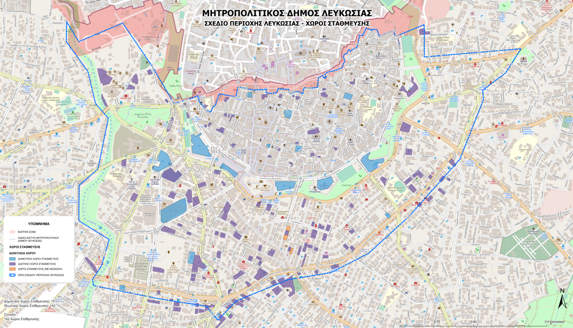
The Data Behind the Makariou Avenue Controversy
New municipal mapping data obtained by Politis cuts straight through the central argument surrounding Nicosia’s commercial triangle. Across the Nicosia City Centre Area Plan, encompassing the walled city and the commercial core around Makariou, Stasikratous, and Evagorou avenues, municipal records identify 162 organized parking facilities (143 private, 16 municipal, and three leased municipal lots) alongside 1,397 general on-street spaces and 87 dedicated disability bays. Combined, total parking supply exceeds 3,000 spaces.
For months, merchant groups lobbying to reopen Makariou Avenue to private cars have claimed that customers stay away because nowhere exists to park. These maps demonstrate that physical parking supply is substantial. The real failure exposed by the municipal audit is that authorities have mapped concrete spaces on paper while collecting zero operational data on hourly occupancy, parking duration, turnover rates, or walking distances to the shopping promenade.
Why Blind Parking Generates Gridlock and Merchant Frustration
Understanding both sides of the Makariou dispute requires separating real operational friction from flawed traffic remedies. Shopkeepers rightly complain that visitors feel lost trying to reach the commercial core. When drivers enter central Nicosia without knowing which of the 162 facilities have vacant spaces, what private operators charge, or how close those lots sit to Makariou Avenue, they circle residential side streets in frustration before giving up and driving to suburban malls.
However, reopening Makariou Avenue to through-traffic, as contemplated in stalled municipal proposals, will not solve a parking information deficit:
- Zero parking capacity added: Allowing private cars to drive down Makariou Avenue adds zero curbside parking spaces to a shared-space promenade built without parking bays. It simply creates slow-moving traffic queues outside shop windows.
- Safe System hazard: Mixing distracted motorists scanning for non-existent parking spots with families, children, and elderly pedestrians walking on level shared surfaces violates basic Safe System speed and separation standards.
- Transit paralysis and EU funding risk: Blocking the avenue with private cars traps public buses in congestion while risking the clawback of nearly €21 million in European Union cohesion funding tied to traffic reduction.
Turning Static Maps into Intelligent Transport Systems
European cities that revitalized historic shopping districts, such as Brussels, Ljubljana, and Madrid, recognized that drivers do not need cars on the shopping street itself; they need seamless digital guidance to perimeter parking and frequent last-mile transit. Nicosia Municipality and the Ministry of Transport can resolve the parking perception gap immediately using Intelligent Transport Systems (ITS):
- Real-time occupancy sensors and open data: Integrating public and participating private parking facilities into a unified digital platform connected to the Cyprus National Access Point allows motorists to see live space availability, pricing, and exact walking minutes to Makariou Avenue on smartphone navigation apps before leaving home.
- Dynamic variable message signs (VMS): Installing digital guidance signs along primary entry corridors (such as Griva Digeni, Spyrou Kyprianou, and Stasinou) directs arriving drivers straight to open parking garages around the perimeter of the commercial triangle, eliminating aimless circling.
- Enforcing turnover and disability bays: Protecting the 87 on-street disability bays and short-stay retail spaces with automated camera enforcement (scan-cars) prevents all-day commuter storage and ensures high customer turnover throughout shopping hours.
- Frequent, signal-prioritised Park and Ride shuttles: Pairing perimeter parking lots with electric shuttle buses granted Transit Signal Priority (TSP) at junctions delivers shoppers directly into the Makariou loop every five to seven minutes.
Central Nicosia already possesses more than 3,000 parking spaces. Connecting drivers to those existing spaces through smart technology and clean transit will support local businesses far more effectively than surrendering Nicosia's flagship pedestrian promenade back to traffic gridlock.
--- Reference: Based on municipal parking mapping data reported by [Politis](https://www.politis.com.cy/politis-news/koinonia/1069159/ekhei-parkinghk-to-kentro-tis-lefkosias-ti-apokalyptoyn-oi-khartes-toy-dimoy-poy-eksasfalise-o-p).
About ITS Cyprus
ITS Cyprus brings together public authorities, research and industry to advance Intelligent Transport Systems in Cyprus, through initiatives such as Road to Zero Cyprus for road safety.
Learn more about ITS Cyprus →